The following are some typical applications for optical bandpass filters, which can be provided by Evaporated Coatings, Inc.
Medical Industry:
- Ophthalmology
- Vacuum-assisted laser technology and processes are being employed to develop next generation imaging techniques to reveal structural and functional information from the human retina in a
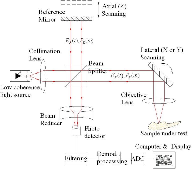
non-destructive and non-invasive manner - Optical Coherence Tomography (OCT) is a laser-assisted technology for retinal imaging
- Vacuum-assisted laser technology and processes are being employed to develop next generation imaging techniques to reveal structural and functional information from the human retina in a
*Adapted from Vacuum Technology & Coating Magazine from February
2018
Narrow Band-Pass Filters for Gesture Recognition Systems
- Distance Measurement Systems
- Gesture recognition and TOF systems like 3D imaging applications require best transmission performance in the range of the illumination wavelength (Laser or LED source) for a wide field of view. Outside the bandpass an extraordinary blocking is required to suppress the ambient illumination for a better contrast. The filters can be provided in various sizes and if required with B-Stage Epoxy or Solderable coating frames for optional sealing.
- Multi-purpose cameras for the automotive market
- 3D imaging applications
NIR Band-Pass Filters for 800-1100 nm
- Range finder (golf/hunting)
- Distance meter for building and construction
- Automotive sensor systems: Adaptive cruise control (ACC), Lane departure warning (LDW)
- Industrial safety systems (safety light curtains)
- Good for environmental stability
- Enabling superior signal-to-noise-ratio in NIR sensing applications
- Highly stable spectral characteristics, also under changing environment and temperature
- Spectral design and flexibility for central wavelength, transmission bandwidth, blocking ranges and levels
*Adapted from Optic Balzers company website
From ground to air, explore the types of LiDAR systems
1. Profiling LiDAR was the first type of Light Detection and Ranging used in the 1980s for single line features such as power lines. Profiling LiDAR sends out an individual pulse in one line. It measures height along a single transect with a fixed Nadir angle.
2. Small Footprint LiDAR is what we use today. Small-footprint LiDAR scans at about 20 degrees moving backwards and forwards (scan angle). If it goes beyond 20 degrees, the LiDAR instrument may start seeing the sides of trees instead of straight down.
Two types of LIDAR are topographic and bathymetric:
i. Topographic LIDAR maps the land typically using near-infrared light.
ii. Bathymetric LiDAR uses water-penetrating green light to measure seafloor and riverbed elevations.
3. Large Footprint LiDAR uses full waveforms and averages LiDAR returns in 20m footprints. But it’s very difficult to get terrain from large footprint LiDAR because you get a pulse return based on a larger area which could be sloping. There are generally less applications for large footprint LiDAR. Only SLICER (Scanning Lidar Imager of Canopies by Echo Recovery) and LVIS (Laser Vegetation Imaging Sensor) both built by NASA and are experimental.
4. Ground-based LiDAR sits on a tripod and scans the hemisphere. Ground-based LiDAR is good for scanning buildings. It’s used in geology, forestry, and heritage preservation and construction applications.
LiDAR applications professionals use right now
Light detection and ranging is being used every day in surveying, forestry, urban planning and more. Here are a couple of LiDAR applications that stand out:
- Riparian ecologists use LiDAR to delineate stream orders. With a LiDAR-derived DEM, tributaries become clear. It’s easier to see where they go far superior to standard aerial photography.
- Foresters use LiDAR to better understand forest structure and shape of the trees because one light pulse could have multiple returns. As with the case of trees, LiDAR systems can record information starting from the top of the canopy through the canopy all the way to the ground.
- If Google’s self-driving car got pulled over by the cops, how would it react? Self-driving cars use Light Detection and Ranging. The first secret behind Google’s self-driving car is LiDAR scanner. It detects pedestrians, cyclists’ stop signs and other obstacles.
- Archaeologists have used LiDAR to find subtle variations in elevation on the ground. It was a bit of a surprise when archaeologists found square patterns on the ground over vegetation. Later, they found these square patterns were ancient buildings and pyramids built by ancient Mayan and Egyptian civilizations.
Websites and sources regarding GIS:
https://gisgeography.com/lidar-light-detection-and-ranging/
http://kustomsignals.com/products/product_category/category/laser
https://www.eagleview.com/product/pictometry-imagery/specialized-mapping/

